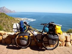
Arriving in Mocimbao at dusk a few days ago, I was exhausted after a long day and booked into the 1st shabby overpriced room I could find. The bed collapsed during the night, but fortunately there was a spare. I wanted to get Mocambique behind me, and left early the following morning for Palma and the border. After asking directions I was surprised to find that the road was tarred, and assumed it was a recent development as I'd been (reliably) informed otherwise. Twice more I was told that I was indeed on my way to Palma, until after 25 k's I realised that this was the same road I'd used the previous evening. The following day I made it to Palma, and asking for a room or camp site I was pointed down a track which disappeared amongst the palm trees. Enquiring if the place was further than a km, I was told that it was indeed 26 km's, but the road was good (via bon! - thumbs up) and the facilities were of the best. I was a bit apprehensive realizing that he was probably talking about Quionga and I'd been (reliably) informed that the road was terrible. However, it was still early in the day and I had to go that way to reach the border. Two k's later I was sliding down donga's and dragging my bike across sand dunes, but I didn't have the time or energy to concern myself any forther with the misinformation. Three and a half hours (and 22 k's later) I dragged old Saartjie by her ears into a village and, unsure if I had the strength to continue, enquired about the distance left to Quionga. I was informed that I had indeed reached Quionga, and my spirits sank as I couldn't see any nice hotel or camp site (where was that shower and cold drink I'd been looking forward to?). Some of the locals helped me plough through the sand to the far end of the village where a log cabin stood apart on a sprawling plot. There I met Andre and his wife who run a mission station. They were rather amused to hear that they were operating a hotel and camp site, as they'd allowed passing travellers to camp on their grounds from time to time. As it turned out I did camp there and even had a shower (the fresh bread for breakfast was an added bonus). I needed the energy from that bread, because there was another 25 k's of the soft and rough stuff before crossing the river by motorboat into Tanzania. Talking about directions, I think Malawians have been the most inventive so far. A favourite distance there is 9 km (which turned out to be anything from 2 k's to 37 k's). Weather predictions are just a tricky. In Blantyre I pointed out the overcast sky and asked the locals if it meant rain. The response of "no" was still echoeing in the passages when someone shouted from outside to remove washing from the line (it rained for the next 3 days). One day in Mocambique I looked at the heavy sky and asked the guy cycling alongside whether it meant rain (of course he said no). Five minutes later we were sheltering from the heavy downpour under the thatched roof of a roadside market. I did my laundry this am, and when I hung it out the locals predicted no rain. This is already my second day in Mtwara, and hopefully I don't have to stay a third. Distances since Pemba have been:- Sunate 85 km; Macomia 122 km; Mocimbao 149 km; Mocimbao Bay 54 km; Quionga 109 km; and Mtwara 65 km.