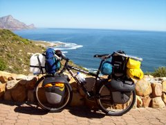


In a moment of madness I found myself running my fingers across the map of Sumatra in Braille-like fashion (don't worry, I've recovered from the eye infection). I was trying to decypher the hills, but the map remained flat - not so in reality! Although there were a number of comfortable cycling stretches along the coastline, through many villages, rice paddies, and coconut groves, the overwhelming impression is one of many steep hills. It seems to me that the National Parks with their lush indigenous rain-forests exist simply because those slopes are too steep to accommodate the population or to allow for agriculture. Probably the toughest day which Leana and I have had so far was through such a park, and for the first time on this journey I pushed my bike on a paved road. Dragging the stubborn and heavily-laden "Saartjie" up that hill by her ears was no fun at all, and it prompted me to successfully make the extra effort to subsequently stay on the bike. From Benkunat village on the West coast we crossed the back-bone of the island again (another National Park!), where we found that the downhill section had been partially obliterated by a landslide. There were a number of exciting moments slipping through the clay in the rain, and by the time we were off the mountain our bikes must have looked like two moving ant-hills (fortunately there was a hosepipe at our overnight accommodation). Once or twice we camped in what we thought were discreet spots, but the villagers have an uncanny ability to sniff out tourists - making us the "attraction of the week" (particularly if your camp is practically on top of their water supply - which we took to be an abandoned well). We spent a couple of luxury nights in a "fancy" hotel in Bandarlampung where Leana extended her visa. Today we left Sumatra and crossed the Sunda Strait on a large ferry which also carries cars, busses and trucks. During the voyage we had views of the infamous Krakatao, still grumbling and steaming in the distance. Now we're in the town of Cilegon on Java Island (about 15 k's from the ferry port at Merak), and I'm sipping "mokka coffee" on my first day in Java. Daily distances cycled since Benkulu have been:- Seluma 61 km; Manna 83 km; Bintuhan 76 km; Pugung Tampak 85 km; Krui 37 km; Benkunat 87 km; Kotaagung 70 km; Pringsewu 60 km; Bandarlampung 38 km; Kalianda 63 km; and Cilegon 46 km. Total distance so far on this trip is 56 694 km.


1 comment:
Incredible journey! Three years today! I just happened to stumble on your blog just now; I will definitely be showing this to my friends. You are an inspiration!
Luke
Post a Comment