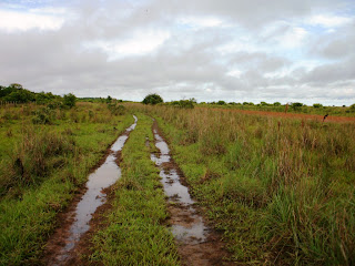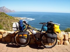


I was desparate to get some decent info before heading through Eastern Columbia along the Rio Meta towards Puerto Carreño and the Venezuelan border. I was aware that the river was widely used for transport, but due to the flood plains of this big Orinoco tributary the map indicated that I would usually be quite a distance from the water. However, locals don´t travel all the way along this route, and I was told that the road was anything from 200 to 350 km long (or just far). For 2 days I battled along a terrible bumpy and dusty road, and I found it better to cycle on paths alongside the road where possible. Then 2 things happened:- I branched off that road onto a series of jeep-tracks and footpaths, and the rain started. Often over the following days the water stood so deep that I couldn´t make out the track I should be cycling on. I had many spectacular falls during that time. There were also many times when I had to drag my poor old bike through sucking black swamps, destroying my sandles in the process. Unfortunately my camera didn´t survive all the falls and the water, so the last picture I took on this section is the one where my bike is lying in the road on a good day. However, a strange thing happened, and I picked up a Blackberry in the middle of nowhere the day after my camera broke (it seemed slightly damaged and didn´t seem to be in working order, but I kept it anyway). I lost my way quite a number of times, as it was often diffucult to decide which one of a maze of tracks was the actual highway. So much for complaining. This part of the country is cattle-ranching land, and I camped at farmsteads quite a number of times. I found the farm people and the cowboys to be wonderful people, and they were more than willing to accommodate me. Without fail I was offered food as well, usually before I could even pitch my tent (always under the cover of their roof, to shelter from the rain). There is only one proper town about half-way along this route, an interesting place called Prima Vera. I stopped in there to do some shopping, and before I knew it a crowd had gathered and I was being interviewed by the local TV channel who followed me all the way out of town with their cameras. All along the way I still couldn´t figure out how far the end of the road at Puerto Carreño was, so I just made sure that I had enough food with me for a few days, but clean drinking water started to become a problem in some isolated areas later on. I imagined that I was bullet-proof, and a few times I drank water from suspect sources. As can be expected, the suspect water took it´s toll and caused me to become extremely ill, not being able to take in any food or drink for a couple of days (eventually I collapsed at a farmhouse early one day, where I lay until the following morning when I felt strong enough to continue). After what seemed like forever, 750 km later, I rolled into Puerto Carreño where the local Fire Brigade have been happy to evacuate an office where I´ve been able to camp for a couple of days. Further, I´ve been able to charge the battery of the Blackberry which I´d picked up, and I was happy to find that at least the camera still works (so I am able to take some simple pictures). Daily distances cycled since I last reported distances from Cali have been:- Andalucia 122 km; Armenia 90 km; Cajamarca 37 km; Ibague 78 km; Fusa 103 km; Bogota 63 km; Villavicencio 90 km; Puerto Lopez 109 km; Puerto Gaitan 115 km; Matanegra 57 km; Karim Aguas 54 km; Finca Carillo 68 km; Finca Marabre 44 km; Finca Virgen 58 km; Prima Vera 31 km; Santa Barbara 60 km; Antiguaneuvo 56 km; La Vendicion 74 km; Rio El Chiqui Chaque 62 km; La Esperanza 46 km; Finca Tienda 65 km; Puerto Carreño 75 km. The total distance cycled in South America to date is 19 317 km, and total for the trip is 85 804 km.


No comments:
Post a Comment