Saturday, 22 August 2015
TACKLING THE TAKLAMAKAN
PICTURES OF THE NW CHINESE DESERT (TAKLAMAKAN DESERT)
(THIS POST IS INCOMPLETE, WILL BE FINISHED LATER, PLEASE BEAR WITH ME)
As I left the oasis city of Kashgar for the Taklamakan desert, old Mao was there at his post to give me a "farewell" sendoff (or was that "good riddance"?).
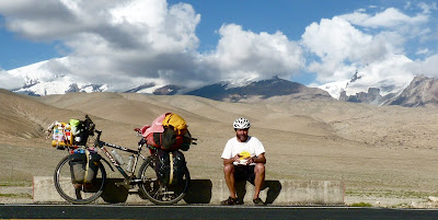
At first there was the occasional oasis town, as well as the big town of Atushi. Then just some dusty really crappy little clay-brick villages, mostly catering to truck repairs and basic food and drinks.
The Taklamakan is apparently the 2nd largest sandy desert on earth. Beforehand I had worried about the wind direction and so forth. Well, no need to worry, as the wind changes direction at will. Also, it may be cloudy (probably dust clouds) cutting out the sun, and the the next thing you know you are being barbequed alive!
I hope you like pictures of desert mountains and other desert scenery, as there is not much variety.
Ghost towns are plentiful in certain parts of the Taklamakan. For some reason they have been closed down and left to decay. Some of the buildings still seem habitable. In the top picture is a view of many graves (in the background). So at least at one time there were people living here. Often these ghost towns were a disappointment to me, as I thought there may be water or a Coke, or something.
About 500 km after Kashgar I got to Aksu, a much bigger town than I had expected. The rain came down, and I got stuck in the city for the night. I found my way down to the railway station, where there are often cheap rooms, but because if was a foreigner in an out-of-the-way town they refused me. It was pouring with rain, and I walked into a little bar/restaurant to shelter and think about what to do. (This was already the 4th place I had gone into, the other 3 had chased me out, because of my beard, I guess). As these people were busy chasing me out, a local Chinese guy and his friend stopped them and asked me in broken English where I was from. Then they invited me to sit at their table, they shared their food with me and bought me a drink. When Sheia discovered that I did not have a place to stay, he invited me to sleep on his couch, just around the corner (one of my lucky days).
Daily distances cycled:- Atushi district 101 km; Service village 83 km; Rock Desert 107 km; Tollgate camp 86 km; Uyghur town 67 km; Aksu 78 km; Road camp 130 km; Kuqa district 122 km; Dust junction 97 km; Hill camp 102 km; Bayingol 93 km; Bosten Lake area 77 km; Desert camp 115 km; Service area 68 km; Turpan turn 37 km; and Turpan 103 km. Total so far is 131 138 km.
Wednesday, 12 August 2015
THE CHINESE KARAKORAM
PICTURES OF THE KARAKORAM FROM TASHKURGAN TO KASHGAR.
(RELAX, THIS POST IS INCOMPLETE, BUT YOU CAN LOOK AT THE PICS IN THE MEAN TIME)
Daily distances cycled:- Tashkurgan to "the pass" 64 km; Reservoir gorge 80 km; Stone camp 91 km; and Kashgar 65 km. Total so far is 129 472 km.
Sunday, 2 August 2015
NW CHINA - URUMQI AND KASHGAR
FIRSTLY, HERE ARE SOME PICTURES ALONG THE WAY IN URUMQI, CAPITAL OF THE JINXIANG PROVINCE IN NORTH WESTERN CHINA.
My efforts to get to the western extremes of China have resulted in somewhat of an epic journey in itself (without riding the bike). From Lanzhou, where I produced my previous pathetic blog update, I have headed constantly in that westerly direction. My objective being to get as close to the China/Pakistan border as possible, where I have been before (from the Pakistan side – without being able to enter China at that time). Hard seats on crowded trains were the order of the day for 24hrs at a time. Old Saartjie (my bike) and baggage which was booked into the cargo department never arrived on the same day as me. So, first stop was Urumqi (Wulumiqi Nan to most Chinese further East – which makes things rather confusing to someone like me who does not speak the language). Anyway, Urumqi is a large modern city, and the capital of this vast western Xingjian province. If this province was a country on its own, apparently it would be the 8th largest country in the world. However, the provincial population is only 4% of the total Chinese population. There is a notable security tension in the city, after the 2009 rebellion (military, police, and security checks all over the show – even armored cars outside shopping malls). I booked an onward ticket at the quiet ticket office in the city (the train station ticket offices are all absolutely chaotic, and you can expect to be in “pushy” que’s for hours). Then I stayed over in the Mai Tan Hostel, central and quite a pleasant place. This province is home to the largely Moslem Uighur people, who have their own style of food, mostly based on mutton (where in the rest of China the staple meat is pork). The following pictures are just some shots around Urumqi.
MY NEXT STOP WAS KASHGAR, THE MOST WESTERN CITY IN CHINA.
One way of geographically placing Kashgar is to realise that in distance this city is closer to Damascus than to Beijing. The city has been a major central Asian trading post for thousands of years. The population in Kashgar is mostly Uighur, there is a central “Old Town”, around an important mosque. Unfortunately a large part of the old town has been demolished, and other parts have/are being “renovated” to look somewhat artificial and touristy. Fortunately there is still a strong “old fashioned” Uighur way of life in Kashgar (where I happen to be at the moment). The Old Town Youth Hostel is a great place to meet other travellers, especially touring cyclists, for which the place is known. Nothing fancy, but with cheap beds, outside courtyard where you can keep (and even wash your bike), and a secure temporary haven from the “real world” – which I am often too close to. For years I have been looking forward to experiencing Kashgar, and I am not disappointed. Although this city is not a big one (actually it is a desert oasis), it certainly has a modern aspect to it – after all, it is part of a rapidly “developing” China! So, the following pictures are from around Kashgar (mostly the old town).
Now you are probably wondering where I will be off to after this. Well, I was hoping to be able to somehow (by miracle) get up to the Pakistan border. (Actually, I also wanted to see if there was anything left of my old gloves which I had strapped to the post at KM 0 at the top of the Khungerab pass!). Unfortunately the area beyond Tashkurgan is a military restricted area, and I will not be allowed in there on my own (especially with bike).
Subscribe to:
Comments (Atom)


